
Google Street View Vancouver
Google Map’s Street View service has officially launched in Canada and includes sidewalk-level images of Vancouver, Squamish, Whistler, Banff, Calgary, Kitchener/Waterloo, Toronto, Ottawa, Montreal and Quebec. Vancouver’s coverage also includes Richmond, New Westminster, Surrey, and all Metro Vancouver cities as far East as Chilliwack.
This morning at the launch we got the full rundown of the service, its privacy measures, and how the City of Vancouver, Tourism BC, and other partners such as ChicWalks will integrate Street Views.
Here’s how it works: Basically the Google car drives around cities with a big camera on top and snaps images to map street-level views. The images from Vancouver were taken in May and they’re currently mapping other cities across BC. There have been privacy concerns in the past such as: what if street views catches my car running a red light or what if it captures someone where they weren’t supposed to be? To address this, Google Maps has blurred all faces and license plates in Street View. They also only take pictures in public locations and offer up a super simple way to report an issue if you’d like something removed.
Mike Pegg, Product Marketing Manager (and Google Maps blogger) was on hand to moderate the panel and introduce Luc Vincent. Also from Google Maps, Vincent gave us a full run through of features. This included finding our current location, getting walking directions (with views along the way) and understanding that the circular and square highlights on the view are referred to as “pancakes” and “waffles”. Even Pegman was on hand to greet the crowd.
William Bakker from Tourism BC did a demo of their HelloBC.com Google Map integration as well. The tool, new to the Province, will assist in “virtual tourism” as many people plan and plot their trips online in advance.
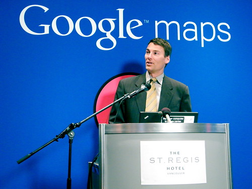
Vancouver’s Mayor Gregor Robertson was also on hand to say a few words about Vancouver’s sites and images, mostly including Vancouver 2010 Olympic venues such as Canada Hockey Place and the Four Host First Nations site. Mike Pegg assured everyone that buildings and venues that are currently under construction for 2010 will be re-captured/re-mapped once complete.
Google Maps Street View is currently mapping other cities in British Columbia such as Cranbrook, Gold River, Kamloops, Kimberly, Merritt, Pemberton, Port Hardy, Prince George, Prince Rupert, and Revelstoke.


7 Comments — Comments Are Closed
My students have already found numerous exceptions to the “blur” rule. And some very strange blurring as well… a wheel blurred but not the car, a leg blurred but not the face.
I think they have an automated system for the blurring but people can also file a report to have things blurred out as well.
That’s swank! I don’t have to go outside my house to see my house…Oh, kinda creepy. Thank gawd it’s not real-time…
I noticed the google street view function, a few years ago when I was on vacation in the states with my friends. I was like this is neat but a tad to big brother-ish for me.
Though I do have to admit that I checked it out this morning just to see my old street and the big house that’s replacing my old one. And of course to see if I was/my car was spotted when I spotted it driving around.
We have had street view a while now in the UK and despite the predictable shouting of a few about security issues (the possibility of people checking out properties before breaking in etc, well people can just walk past a house and get the same view, so this point is moot in my mind), I have found it invaluable.
This year I have had to go to s few places that I was unsure of how to get to and by using streetview in advance, I was able to pick up local landmarks to make my journey there much easier. I would actually be walking down the road and recognise places. Spent a good time yesterday, reliving trips I made in BC last year and will be a great aid to helping me know my way around when I move there for good.
[…] For the eight installment of my Then and Now Vancouver photography series I thought I would change things up a bit. I’m going to be using images from the City of Vancouver Archives but instead of modern day images for the “now” portion of the post, I will be using Google Street Views. […]
We thank Google Canada so much for including us as a Street View on Google Maps partner, along with City of Vancouver and Tourism BC! Also, thank you Miss604 for mentioning us on your blog! Visit our site often as we are constantly updating shopping walks for Paris and Vancouver, and adding new cities worldwide:
Site: http://www.chicwalks.com
Follow Ms Chic around the world on Twitter: http://twitter.com/chicwalksCEO