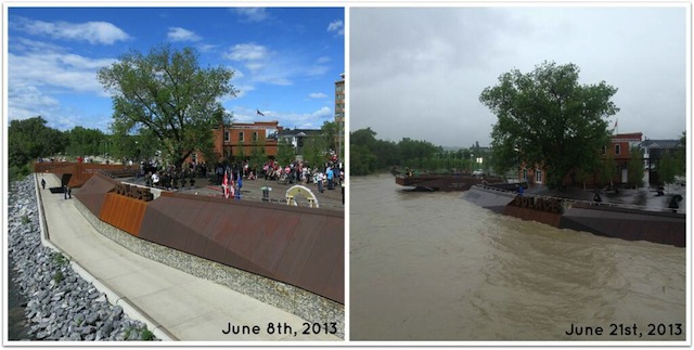
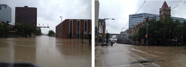
Southern Alberta has been devastated by floods and rising river waters over the last week leaving the City of Calgary, and many surrounding areas, in a state of emergency.
Most significant is a large amount of rainfall — up to 200 millimetres in some places. Add in ground that is already saturated because of some more modest precipitation — about 40 millimetres — preceding the deluge. Combine that with areas that were still frozen not far below the surface and a local geography that encourages water to run down hill quickly, and there’s a recipe for this week’s devastation… On June 20, Calgary experienced record one-day rainfall with 45 millimetres coming down. The previous record was 35.1 millimetres, set in 1964… [Source: CBC]
Slowly looking on as the river rises and the city shuts down, watching the murky water fill the streets, and then waiting and waiting for it to retreat — all while power is cut and supplies run low. This has been an incredible situation for hundreds of thousands of people affected in Alberta (including Banff, Canmore, Red Deer, and more) with highways and bridges washed out, disconnecting communities.
The Canadian Red Cross has teams from across the country have been working around the clock to help those in Alberta. As a member of their Social Team, they have kept me (and the others who are all across Canada) in the loop when it comes to spreading the word about the work they are doing and what might help the most.
Here’s the latest from the Canadian Red Cross:
- The Red Cross is responding in Alberta, helping in shelters by providing support from our volunteers, as well as cots, blankets, hygiene kits and other items that will help those evacuated feel safe and comfortable.
- In disasters like this, a lot of times families get separated from one another, or can not contact each other, so the Red Cross sets up a registry for anyone in shelters. We also have a family reunification line where people can call if they need help locating loved ones.
- At reception centres in Alberta, Red Cross volunteers are working to give people affected by the flooding information they might need – ie, where can they get other supports, how do they contact insurance companies, etc.
- The Red Cross is also working to support various First Nations communities that have also been affected.
- Across Canada, our teams have mobilized and volunteers from begun deploying. It’s an all-hands-on-deck kind of situation. Our volunteers are highly trained and ready to work in these situations.
- We get a lot of questions from people wanting to donate clothes, food or other items. The Red Cross does not have the capacity to accept these kinds of gifts, but we can refer you to other agencies that can.
- The best way to support the Red Cross is through a financial donation by calling 1-800-418-1111 or by texting REDCROSS or ROUGE to 30333, texting ABHELP to 4664 for Rogers customers. You can also donate online.
The Red Cross strongly encourages Albertans impacted by flooding to heed the warnings of officials. Updated information on evacuations is listed on the Alberta Emergency Alert website as well as the City of Calgary website. Follow the Canadian Red Cross on Twitter and Facebook for more information about their work and how you can help.
It’s one of those moments in the life of a Pacific Northwest resident that everyone remembers — where they were, what they heard, what they thought it was. I was only a few months old when Mount St. Helens erupted on May 18, 1980 but from 500km away, people (like my mother) recall hearing the blast and even dusting ash off of their cars. I have seen documentaries over the years and have even blogged about the anniversary of the eruption several times, however I had never been to Mount St. Helens National Volcanic Monument until just this month when John and I stopped in on our way from Vancouver to Vancouver.
Getting to Mount St. Helens
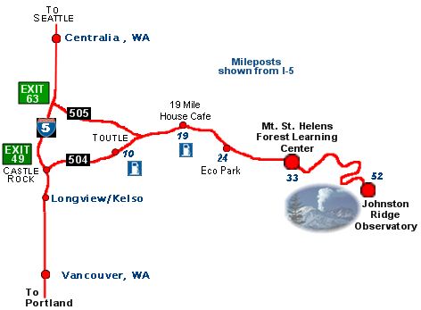
We stayed overnight in Seattle and set out in the morning, plotting our course to Vancouver, Washington with a scenic detour just before Castle Rock so that we could get to Mount St. Helens.
![[PIC] Took a detour driving to #Vancouver today... Vancouver USA! #Van2Van](https://farm9.staticflickr.com/8270/9002355546_c45323688c_z.jpg)
Heading straight down the I-5 for about 2 hours, we turned at Exit 49 and took Highway 504 (Spirit Lake Hwy) all the way to the end of the line.
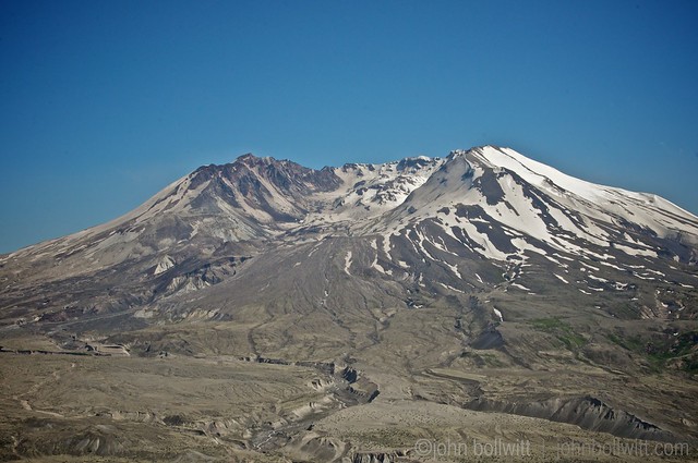
When you first exit the interstate you wind through what resembles cottage country. Lush green properties, RV Parks, rushing rivers and tree-lined twists and turns in the road. You gradually ascend as the road gets wider and the views change from marshy lakes and meadows to sweeping panoramic vistas, getting up to 3,000ft.
Patches of perfectly symmetrical Noble Firs stand tall along sloping mountain ridges and then the snow-covered dome of the volcano appears and disappears, playing Peek-A-Boo as the road winds up and up.
Information signs point out lookouts and visitor centres including the viewpoint at Castle Lake which would be great for a photo op.
Facts About Mount St. Helens
The Mount St. Helens National Volcanic Monument is within the Gifford Pinchot National Forest and managed by the USDA Forest Service. The Monument was established in 1982 to designate 445 km2 (110,000 acres) around Mount St. Helens for research, recreation, and education.
Traditionally known as “Louwala-Clough” or “smoking mountain” to local First Nations, here are a few more facts about the volcano that have been compiled by Carolyn Driedger, Liz Westby, Lisa Faust, Peter Frenzen, Jeanne Bennett, and Michael Clynne for the USGS:
- During the past 4,000 years, Mount St. Helens has erupted more frequently than any other volcano in the Cascade Range.
- 1792: Captain George Vancouver named the volcano for Britain’s ambassador to Spain, Alleyne Fitzherbert, also known as Baron St. Helens.
- March 20, 1980: A magnitude 4.2 earthquake signaled the reawakening of the volcano after 123 years.
- Spring 1980: Rising magma pushed the volcano’s north flank outward 5 feet per day.
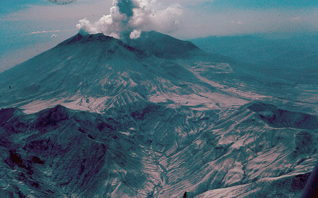
- Morning of May 18, 1980: The largest terrestrial landslide in recorded history reduced the summit by 1,300 feet and triggered a lateral blast.
- Within 3 minutes, the lateral blast, traveling at more than 300 miles per hour, blew down and scorched 230 square miles of forest.
- The volcanic ash cloud drifted east across the United States in 3 days and encircled Earth in 15 days.
- The May 18, 1980 eruption was the most economically destructive volcanic event in U.S. history.
- Small plants and trees beneath winter snow, and roots protected by soil, survived the May 18, 1980 eruption and now thrive.
- During the 1980 to 1986 and the 2004 to 2008 eruptions—Lava oozed onto the crater floor, building domes taller than the Empire State Building and restoring 7 percent of the volume lost in 1980.
Where to Stop
There are several marked viewpoints along the highway where you can stop and take photos. For a closer look and more information about the monument, you can stop into one of these visitor centres which feature scheduled talks, interpretive walks, and more:
Mount St. Helens Visitor Center at Silver Lake (3029 Spirit Lake Hwy)
Science and Learning Center at Coldwater (North Side) 1900 Spirit Lake Hwy
Forest Learning Centre (Highway 504 Milepost 33)
Pine Creek Information Center (South Side) 15311 Forest Road 90
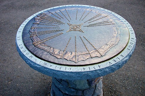
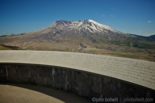
Johnston Ridge Observatory (West Side) 24000 Spirit Lake Highway
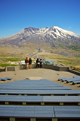
The two top recommended visitor centres are Johnston Ridge Observatory ($8 per person, well worth it) and the Mount St. Helens Forest Learning Center (free admission). We decided to go all the way out to Johnston Ridge, at the very end of the road.
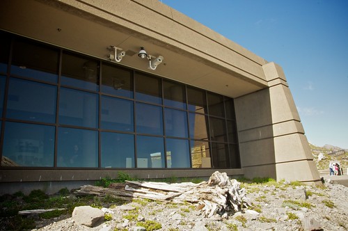
Johnston Ridge Observatory
The parking lot was fairly busy, spotted with trucks, cars, and a food truck with some road trip snack essentials but when we exited our vehicle the haunting wind was the only sound we heard. Signs along the gravel path that connected the lot with the observatory noted that we should have a National Parks Pass for this location and that it could be purchased inside the highly reinforced, bunker-like building.
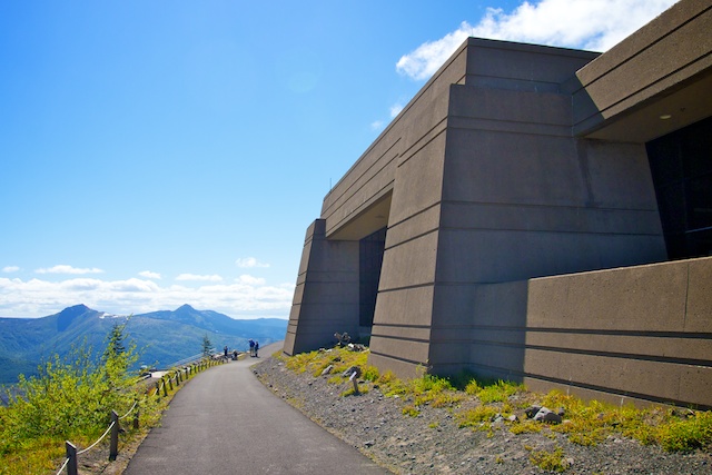
We made a bee-line for the cashier inside the building and paid $8 each for a wristband that gave us admission to the observatory (including exhibits, talks, and movies) and access to the hiking trails. Feeling like I was on a school field trip, I couldn’t wait to soak up the information that was presented within the observatory — I love feeding my brain and learning about Pacific Northwest history.
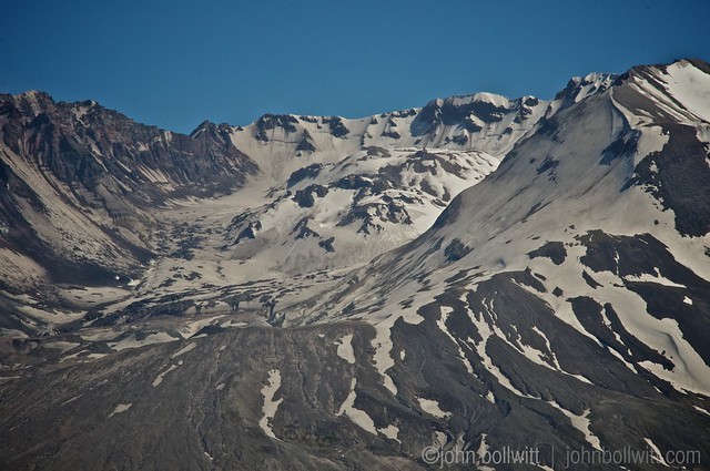
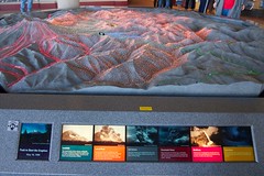
There was a large interactive relief map in the center of the main exhibition hall that told the story of the eruption and lit up the path of the landslides, lateral blast, and lava flow chronologically. Kids played with interactive quizzes and informational boards that had flaps and panels to shift and lift.
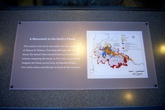
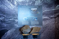
A large tree trunk in the middle of another room bent at a 90 degree angle, demonstrating the power of the eruption’s lateral blast and photography on the walls told the story of those who were in the area on May 18th. Some shared their personal accounts, and others shared the tragic tale of friends who went out in the forest that day and never returned.
Before and After
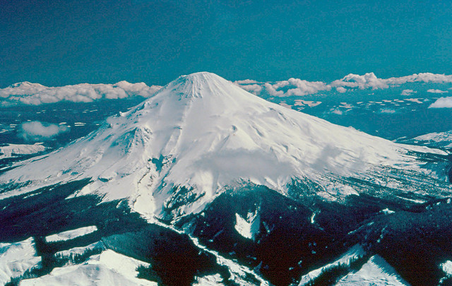
March 28, 1980: Before the eruption. Photo: DNR by Washington State Department of Natural Resources.
March 28, 1980: Before the eruption. Photo: DNR by Washington State Department of Natural Resources.
John’s Photo from June 2013
Views and Trails
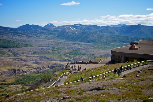
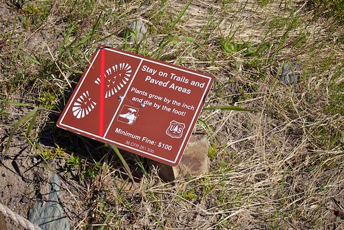
Once you have browsed the inside of the Johnston Ridge Observatory, you can head outside for guided tours, talks, and demonstrations. You can bring your hiking shoes for some of the longer trails otherwise the main pathways around the observatory are paved or have packed gravel, and there are some shorter loops that bring you right back down to the parking lot.
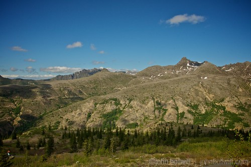
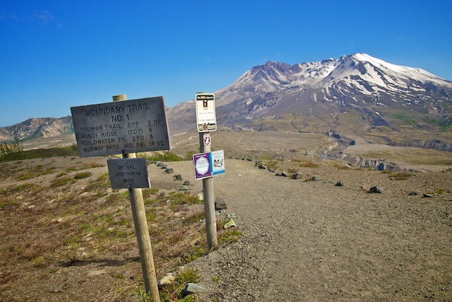
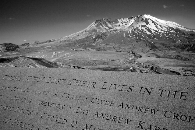
We walked up to a higher path that looked back down at the observatory, and winded around to find a dedication to the 57 people who lost their lives in the eruption. They were loggers, campers, reporters and scientists, and some were never found.
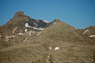
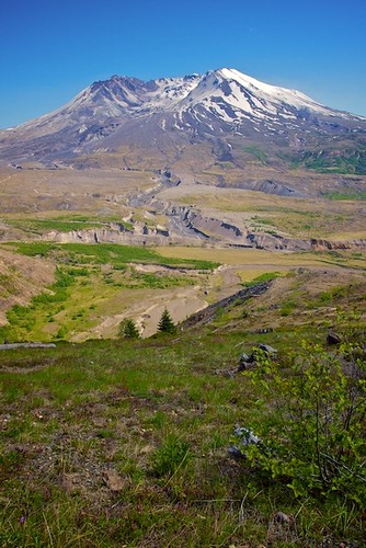
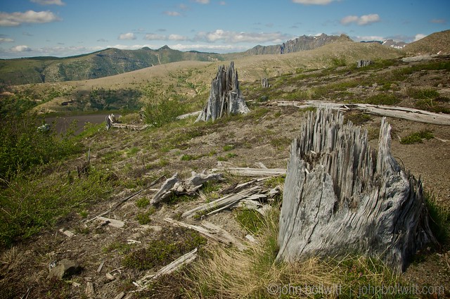
The experience all-in-all is pretty overwhelming. At first you feel in awe of the natural beauty, panning around to absorb the splendour of this spectacular mountainous area with a lake and river in the distance. Then, as silence sinks in and the wind howls you get a chill. You look over at thousands of trees on a ridge that are completely horizontal, as though they were blown down like dominoes that never connected. They have sat there for 30 years, lifeless, grey, and still.
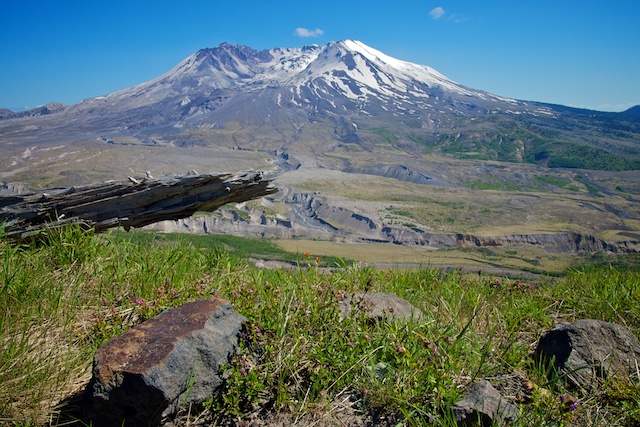
I snapped back quickly as a squirrel came bounding over a log and I realized there’s so much life emerging from this devastation. Orange and purple flowers sprout near the path, trees are growing again, and gradient green grasses and plant-life are creeping closer and closer to the crater.
Resources
When planning your trip, the official Mount St. Helens National Volanic Monument website has all you need. It does take about 60-90 minutes (depending if you stop at lookouts) to get to the Johnston Ridge Observatory from I-5 so it’s better suited for a full day excursion. We did it in a quick trip between Seattle and Vancouver (Washington) and stayed about 2 hours but we would have spent much more time there to do a hike if we could.
From home, you can check out the live Volcano Cam, and follow Mount St. Helens updates on Twitter.
Photos in this post are all by John Bollwitt and me except for the archive images from the Washington State Department of Natural Resources.
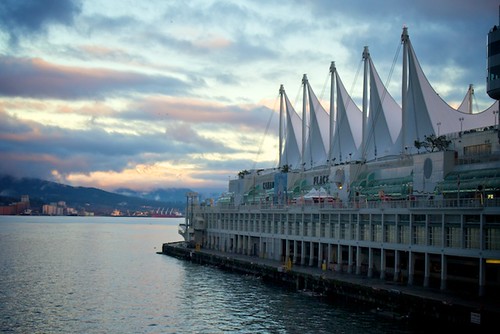
Canada day at Canada Place will host a full day of celebrations on the shores of Downtown Vancouver on July 1st, from the Canada Day Parade to concerts, performances, and attractions. The city will be hopping all the way from the iconic sails down to Harbour Green Park and whether you can make it out or not, you can still play a part in Canada Day by sharing a patriotic picture with Canada Place.
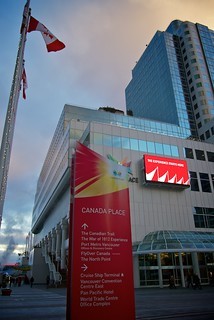
Your Face at Canada Place Mural
Canada Place is creating a one of a kind mural for the Canadian Trail and you can be one of the thousands to contribute your smiling face this Canada Day. The Canadian Trail is home to Canada Five Foundations, Canada’s Communities Walk, FlyOver Canada (Opening late June 2013) and the War of 1812 Experience. The Your Face at Canada Place Mural will feature the faces of hundreds of Canadians (like you) who have shared a photo showing their Canadian pride.
Here’s how you can submit your photo:
- Post a great Canadian photo of yourself at www.canp.lc starting right now.
OR
- Come to Canada Day at Canada Place and use their giant 8 foot Canadian flag as a backdrop to post. The backdrop will be available from 10:00am to 6:00pm at the south end of the Canadian Trail. Then come see if your smile is shining as part of a mural when it is unveiled this summer (later in July).*

You can keep track of all activities by using the Canada Place mobile app for iPhone and Android. Follow Canada Place on Facebook and Twitter too.
Miss604 is a proud Official Media Partner of Canada Day at Canada Place.
* Some photos may not be used due to quality or content. Canada Place reserves the right to not use images for any reason.
The second annual Surrey Door Open initiative invites the public to explore local attractions, venues, facilities, historic landmarks, and parks with self-guided tours and free admission all day on Saturday, June 22, 2013.

About Doors Open
The inspiration for Surrey’s Doors Open stems from origins in France where the first Doors Open event (La Journée Portes Ouvertes) took place in 1984. The idea soon spread to neighbouring countries and has since expanded around the globe. Toronto was the first North American city to follow the European lead and launched a high profile event showcasing constructed heritage, architecture and design as a millennium project in 2000. The City of Richmond has hosted the event over the last 4 years, and has grown their community involvement to over 50 open sites throughout Richmond. [Source: Surrey Doors Open]
Featured Surrey Attractions
While there are dozens of venues and attractions open tomorrow, there are a few special events happening around town as well. Here’s the rundown: Continue reading this post ⟩⟩
While I love a crisp, drizzly Vancouver morning sometimes it takes all of my might to slide out of bed and walk over to my computer, never mind running downstairs and down the block for a hot cup of coffee. Having a brewing system in-house is definitely handy.
We have a Keurig system (that does hot or cold beverages) and now there’s a new Keurig MINI Plus Brewing System, for small homes, vacation homes or even right on your desk at work. This mini system produces three different cup sizes, in under two minutes, and comes in several fabulous colours:

Flash (Lime) Green: Though emerald may have been ‘anointed’ colour of the year by Pantone, flash green, a shade of lime, was the real trendsetter on runways including Stella McCartney, DVF and many more.
White: There is nothing sleeker than white on white, particularly in the warm weather.
Cobalt Blue: Historically, cobalt blue’s elegant power has been seen on everything from Chinese Porcelain to Bristol Glass. The hue is back in force on the runways.
This system (retail: $99) uses Keurig K-Cups which come in over 100 varieties of coffee, tea, cocoa, fresh apple cider and more. It’s also officially summer now and while it’s a bit dreary today, the hot weather is certainly on its way. When it does arrive, you can brew up K-Cup Iced Beverages with a Keurig MINI too like French Vanilla Iced Coffee, Iced Tea, and Lemonade Iced Tea.
I have three Keurig MINI Plus Brewing Systems to give away, one in each colour (cobalt blue, white, lime green). Here’s how you can enter to win:
- Leave a comment naming the colour you would prefer or a drink (hot or cold) that you would prepare with the Keurig MINI (1 entry)
- Post the following on Twitter (1 entry)
I will draw three winners at random from all entries at 12:00pm on Friday, June 28, 2013. Follow Keurig on Twitter and Facebook to learn more about their brewing systems and iced beverage options this summer.
Update The winners are: Brandon (Blue), Sarah Carol Anne (White), @KimikoGilbert (Green).